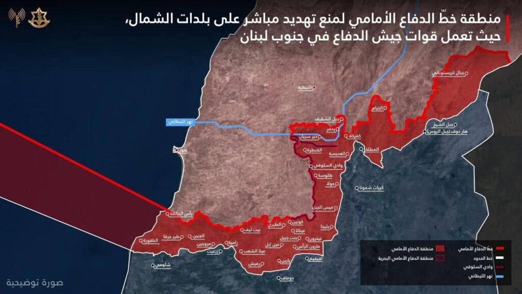
الخارطة لا تقول إن هذه القرى "محتلة بالكامل" عسكرياً وبشكل دائم، بل تصنفها "منطقة عمليات" يهدف الجيش الإسرائيلي لتطهيرها من البنية التحتية للمقاومة لخلق واقع أمني جديد.
Masdar Diplomacy
By Marlene Khalife
The Israeli military has circulated a map marking areas in yellow—depicted in red in the version attached to this report—designated as the “forward defense line.” This map, which has triggered a wave of analysis, remains under close scrutiny, revealing a wide gap between Israel’s propaganda objectives and the hard facts on the ground.
Verified field reports indicate that pro-Israel media outlets have been promoting highly inflated figures regarding the number of villages entered. While claims have been made of control over 55 villages, the military reality prior to the escalation of ground engagements was limited to just five to eight border positions.
To understand the current narrative, it is essential to revisit the recent historical context. Even before the launch of ground operations, Lebanon—from the الجنوب to the البقاع and reaching بيروت—had already been subjected to extensive killing and destruction. Approximately 500 individuals were targeted, alongside major assaults such as the destruction of ten buildings in Beirut’s southern suburbs in a single strike on the eve of Eid al-Adha in 2024. This underscores that current attempts to portray “achievements” are, in part, an effort to obscure earlier violations that breached all established norms.
A closer military assessment of the map—according to two experts—shows a clear exaggeration in the number of included villages. Figures in hostile media escalated from 29 to 55 villages without credible field-based evidence. Moreover, the inclusion of Christian villages such as Rmeish and Ain Ebel within so-called “red zones” is largely a geographic generalization rather than a reflection of actual combat conditions. These villages have no “Resistence “presence, and any Israeli troop movement near their outskirts does not constitute a meaningful strategic or military achievement.
Military analysis further suggests that this map represents Israel’s “maximum attainable ambition” after its broader objectives—namely advancing toward Sidon and reaching the Litani River—were curtailed. It is a “map of aspirations,” not of reality. More than half of the areas marked in red are not under Israeli control. The clearest evidence lies in Israel’s failure to seize the strategic town of Bint Jbeil, despite delaying the implementation of the ceasefire to allow its forces additional time to secure a breakthrough. The town’s resilience in the central sector also prevented Israeli advancement toward Kounine, which Israel nonetheless included on its map. The same applies to villages such as Shaqif and Yohmor in the eastern sector, which residents revisited immediately after the ceasefire, openly defying any notion of occupation.
A symbolic moment that encapsulated the reality of Israeli presence occurred at Beaufort Castle (Qalaat al-Shaqif), where a civilian removed and discarded an Israeli flag. The flag had been placed by a drone during the الحرب, reflecting Israel’s inability to establish permanent military positions inside the fortress. This incident reinforces the conclusion that Israeli presence in many locations amounted to “fire control” and symbolic نمایش rather than stable territorial control.
The Reality of Village Destruction
On another front, a more troubling reality emerges: the systematic policy of “scorched earth” and village demolition. Despite failing to achieve sustained military control at a depth of 10 kilometers—as widely rumored—the actual incursion depth ranged mostly between 2 and 5 kilometers. Nevertheless, Israeli forces carried out widespread destruction of border villages such as Mays al-Jabal, Blida, and Yaroun.
These demolition operations were executed by specialized engineering units using tons of explosives to level entire neighborhoods, or by heavy bulldozers to flatten homes. The objective was to create a buffer zone devoid of civilian infrastructure—arguably the harshest dimension of the conflict.
Today, the ceasefire—though fragile—remains in place amid ongoing Israeli violations through shelling and bulldozing, placing it on the brink of collapse ahead of its scheduled timeline. With a noticeable reduction in Israeli warplane activity compared to pre-ceasefire conditions, residents of southern villages are cautiously assessing the situation. Many have returned to inspect the rubble of their homes, affirming that land Israel failed to occupy militarily will not be abandoned due to demolition policies. The so-called “yellow line” thus remains little more than a paper construct in the face of Lebanese resilience.
Operational Summary
Map Analysis (What Does Israel Claim?)
- The map classifies border villages within a so-called “forward defense line” (red zone).
- Depth: Geographically, this zone does not extend to 10 km in most areas; it ranges between 2 and 5 km, with limited expansion in areas such as Wadi al-Slouqi and toward Khiam.
- Israeli Objective: The map does not claim full and permanent military occupation, but rather defines an “operational zone” aimed at clearing المقاومة infrastructure to establish a new security reality.
Field Realities:
- Control vs. Presence: Inclusion within the “red zone” does not equate to military capture. In towns like Bint Jbeil and Khiam, Israeli forces repeatedly failed to establish sustained control, with clashes continuing until the final moments before the ceasefire.
- Christian Villages (Rmeish, Ain Ebel): Their inclusion is geographic, not operational, as they did not constitute direct threats.
- Shaqif Flag Incident: Confirms that many Israeli actions were demonstrative—brief incursions, flag placement, media documentation, then withdrawal—rather than durable control.
Key Observations:
- Understated Destruction: Israel effectively rendered large parts of frontline villages uninhabitable through systematic demolition, even without maintaining physical presence.
- “55 Villages” Figure: Refers not to occupation, but to villages evacuated or subjected to ground operations and heavy strikes.
The “10 km” Claim and Demolition Reality
- The 10 km depth is misleading if interpreted as sustained territorial control, but accurate if referring to fire reach or strikes in certain sectors.
- Village destruction is carried out through elite engineering units (notably Yahalom), which plant large quantities of explosives or deploy bulldozers to clear structures near the border, ensuring open خطوط رؤية and preventing future المقاومة use.
Conclusion:
The Israeli map represents a projected security buffer and an aspirational operational scope—not an accurate reflection of stable control on the ground. While المقاومة retains mobility across many of these المناطق, the absence of Israeli control does not imply that these villages remain intact. In reality, systematic destruction has rendered many border مناطق uninhabitable, regardless of who holds military advantage at present.